
Vomiting in the Most Picturesque Toilet in the World
In Southern Iceland, (a place unlike anywhere in the world), the Laugavegur trail is unlike any other trail. Never one to argue with the gods of travel, when National Geographic names a hike “One of the Top 20 Trails on the Planet”, you go.

So, let’s go.
First, there are not enough adjectives to fully capture the breathtaking, spectacular, awesome beauty of the Laugavegur. The English (or Icelandic) language just doesn’t have enough take-your-breath-away words.
See? That was only three.
So, while an invitation from NASA to walk on the moon seems unlikely at this point in my life, a close second may be this hike through the Fjallabak Nature Reserve. This four-day trek across the rhyolite mountains, glacier fields, crushed obsidian lava, icy rivers, and boiling mud pots begins at Landmannalauger hot springs, an otherworldly landscape.


seems like a good way to start a trek across the interior of Iceland.
It probably shouldn’t come as a surprise, but naturally occurring hot springs (you know, water heated by actual volcanic magma) can be uncomfortably hot.
“God-that’s-boiling-move-to-the-left-no-wait-now-there’s-a-freezing-cold-spot-over-there-let’s-get-out-we-have-to-hike-anyway.”
Geothermal good times.
Day 1: Landmannalager to Hrafntinnusker: 7.5 miles
The day begins by trekking into the insanely colorful rhyolite mountains. Peaks made of the —science alert— “pink and gray extrusive igneous rock with high silica content that is basically volcanic granite. “
(Pardon that sterile description of these rainbow-spattered and striped mountains that shift colors, act as mood rings for the sun, and look like the puddles mixed with car oil in my driveway.)

The trails quickly succumbed to snowfields interlaced with inky black paths; the remnants of the volcanic dust that all hikers, we eventually come to realize, track around on the bottom of their boots.
And in their socks.
And in their hair.
But I digress.

I’d love to pretend that I’m fitter than I am and say that I was so stunned by the immense landscape that the miles just flew by, but no. Trekking in the snow with a full pack is cardio, full stop. Luckily, when stopping to take a breath, the fumaroles, which are literally cracks in the earth that are spewing forth carbon dioxide (and, even better, sulfur dioxide), are enough to motivate you to move on quickly.


Not so much.
Arriving at the Hrafntinnusker hut, the temperature took a dip into the “just above freezing” range. After piling heavy rocks on the corners of our tent, (because driving tent stakes into the volcanic soil is for those with access to Thor’s hammer and literally no one else), we decided to “check out the map” in the entrance vestibule of the, ahem, heated hut. For, like a half-hour.

We might have checked out the map several times throughout the evening. For several minutes at a time. Did I mention it was heated? Let’s just say that it was cold enough at the outdoor picnic tables that the guy who showed up with a full bottle of Jameson to share was very popular.
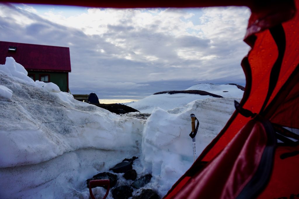
The next morning, after an evening where the sun basically just moved horizontally across the sky, we had an accusatory discussion about who filled the tent with foul, fetid, farts? We then realized we were pitched about 20 feet from a sulfur vent that was permeating our very permeable nylon shelter. Time to move along.
Day 2: Hrafntinnusker to Álftavatn: 7.5 miles
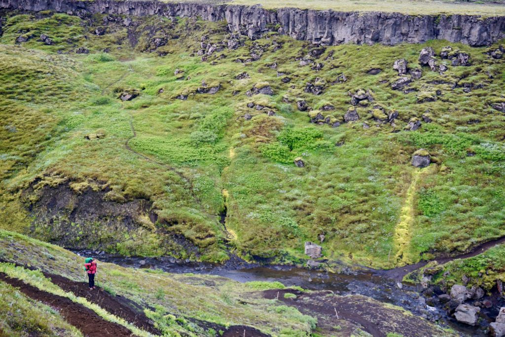
If day one is summed up by the word “snowfields,” then day two, trekking from Hrafntinnusker to our lakeside spot at Álftavatn, is magical. Like hiking through Middle Earth, but without an evil Ringlord and an unfortunate and serious lack of hobbits.
Did you know? Jökull is an Old Norse word that means ” a piece of ice”. Remember that, because it’s about to become important. Today’s track rewarded us with views across the Tindfjallajökull, Eyjafjallajökull, and Mýrdalsjökull glaciers, (see? that’s a lot of broken ice) over precarious snow bridges, alongside snow caves where the sun shines through the ice and it feels like it can’t possibly be more beautiful around the corner—and then it is.


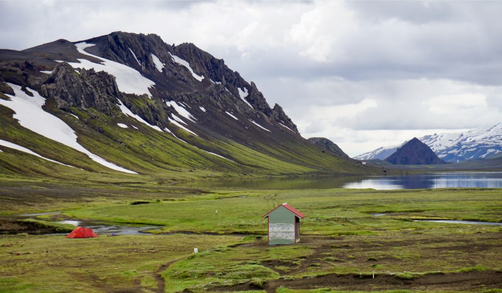
The trail drops down, to the green, grassy, windy “lake of the Whooping Swans” surrounded by volcanoes, where we felt like the only campers in the world.
Day 3: Álftavatn to Emstrur: 10 miles
“Live like a mighty river.”
– Gautama Buddha
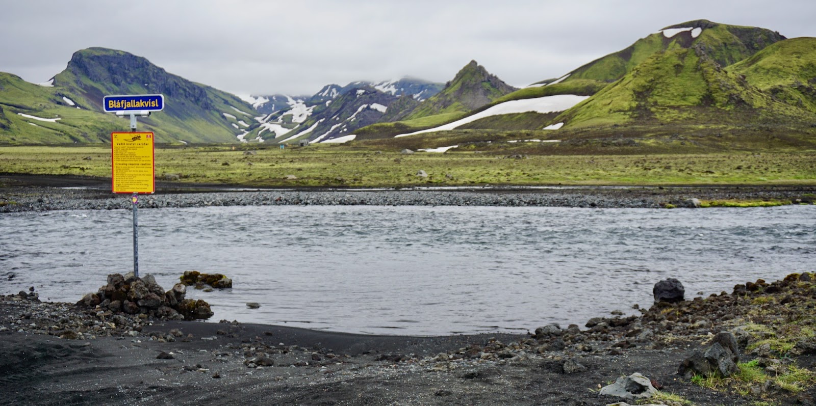
Live like a mighty river all you want, sure. But if you try to cross them, you’d better have a damn good tread on your hiking boots.
Day 3: Bratthálskvísl river, river Kaldaklofskvísl, river Bláfjallakvísl, Innri Emstruá river. I’m not a linguist, but if I were, I’d wager that the suffix –vísl means “yeah, you’re going to get wet.” And we did. We waded some, and some had bridges, but all were so cold that I couldn’t wrap my head around the fact that they were flowing. Water still freezes at 32 degrees, right?


After a day of trying to see if you can die of hypothermia through your feet, we arrive at Emstrur.
Emstrur camp is home to a hut (yeah, we still didn’t make reservations), and one of the most picturesque bathroom houses I have ever seen, anywhere.
I would have appreciated it more had I known I would be spending so much time hanging out there.
147 steps from our camp to the bathroom.
I know this because, after a relatively uneventful evening, setting up camp, watching the sun (not) set, and cooking an unexciting noodle dinner, I woke to the midnight sun.
It was 12:17 am to be precise, sweating and fevered, clawed my way out of my sleeping bag, and sprinted up every one of those 147 stairs to the bathroom at the top. I was pretty sure the fragile Icelandic ecosystem didn’t need to see the contents of my stomach, and I was quite certain that my fellow campers didn’t, either.

I barely made it.
Let’s just say it was an unpleasant experience and that I will spare you the unfortunatue details.
At least the view was nice.
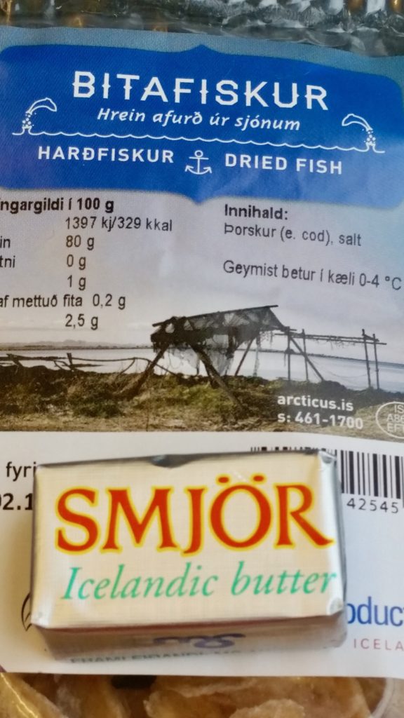
Maybe it was the 2 days prior to the hike spent stuffing our face with local Icelandic favorites: Bæjarins Beztu Pylsur, (Icelandic hotdogs), salty puffin, fatty minke whale, shredded horsemeat, and harðfiskur (dried fish jerky that you smear with butter).
Maybe?
Maybe.
Suffice it to say that the hut keeper earned her pay that day, and it was going to be a pretty miserable remaining 15 kilometers the next morning.
Sidenote that you should file under “good to know”: if you do fall ill on the trail, the hut keepers have basic first aid, paracetamol, emergency contacts, and transport for more serious illness and injury.
Day 4: Ermstrur to Þórsmörk: 9.3 miles
Let me start day 4 by saying that I love that Icelandic has letters that I can’t pronounce. Onward, be it slowly, to Þórsmörk (said: Thorsmork, meaning Thor’s wood), and the first real trees on the trail.
Whatever stomach ailment allowed me to practice running up the steps to the bathroom the night before, it also guaranteed that I was going to be crawling this day. For added excitement, it was our last day on the trail and we had a deadline to meet to make our return bus back to Reykjavík.
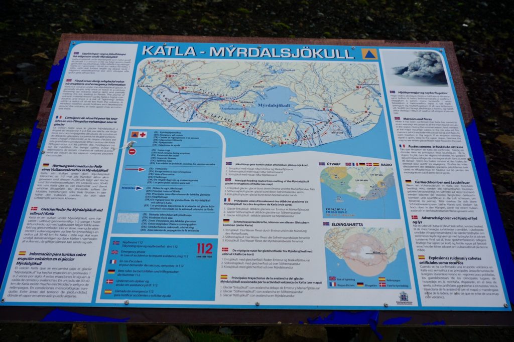
For those needing more incentive to hustle, when leaving Ermstur, hikers are constantly reminded —with signs in no less than 6 languages— that the area you are hiking across is part of the Katla volcano, partially covered by the Mýrdalsjökull icecap.
Aside from an eruption that would “dwarf” the explosion caused by Eyjafjallajökull, (you remember; the “minor” volcanic eruption that shut down air travel in much of Europe for 8 days in 2010?) the sign warns that this geologic wonder could also cause lighting strikes, create accumulations of toxic gases in hollows during windless weather, erupt with enough force to vaporize large chunks of the ice cap (and presumably, anyone unlucky enough to be on the icecap; say, a hiker who was feeling particularly sluggish after an evening of intestinal malcontent), and cause massive flash flooding with whatever is left.
It erupts every 40-80 years. It last erupted in 1918, and it was now 2015.
You do the math.

Luckily, the geology gods allowed us to continue on unfettered, and we “oohed and ahhed” at the Unicorn, the gorgeous Devil’s Bells that seemed to find a way to bloom even in the harshest conditions, and survived the wading of the river Þröng to arrive at Þórsmörk without further incident, and in fact, with smiles; albeit wan smiles, on my part.


Let’s go
We arrived at the trail’s end, Skagfjörðsskáli cabin, with 2 hours to spare. The cabin was full of people who still had food in their stomach from 24 hours before. I was not one of them, so I sat quietly, waiting for fo the bus to transport us back to Reykjavik so I could feebly chew some melba toast for the next 12 hours.

The Laugavegur trail deserves its billing as one of the world’s Top 20; there really are not enough words. It inspires a new appreciation and respect for the variegated, vast, vivid, —and sometimes violent— beauty of the planet.

If it’s even remotely, “maybe-someday”, “sort of” on your radar, do it.
But maybe skip the fish jerky and hotdogs.
Just in case.
Happy trails!